 Jason Woolard is a cartographer working for NOAAs Ocean Service (NOS), the scientific and technical branch of NOAA that measures and predicts coastal and ocean phenomena, protects large areas of the oceans, and works to ensure safe navigation. Woolard explains, NOS is involved everything from producing nautical charts and protecting coral reef habitats to predicting tides and managing the nations marine sanctuaries.
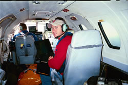
As a cartographer, Woolard conducts fundamental research and development designed to integrate new imaging and mapping technologies into NOAA programs. His job includes work in both the office and the field. Tasks such as processing and disseminating data and writing reports keep him busy in the office. Examples of field tasks include maintaining airborne remote sensing equipment and collecting and processing data on board NOAA aircraft to support shoreline mapping research.
"I go to work everyday and have fun"
Woolard has BS and MS degrees in geography, specializing in GIS as well as remote sensing technologies, which collect data about an object or area without coming into direct physical contact with it. Remote sensing technologies include satellites, sonar, aerial photography, and LIDAR (LIght Detection And Ranging), a technology that uses a laser beam to illuminate an object and produce its image (see related story in the Summer/Fall 2004 newsletter).
Adaptability and good problem-solving skills are important for cartographers, especially when working in the fieldwhich increases the likelihood of encountering challenges such as complicated project logistics and environmental factors like weather and tides. When youre dealing with aircraft, scientific instrumentation, tides, weather and tight schedules, many different kinds of problems can arise, says Woolard. You have to be able to work through the problems without getting flustered, and focus on successfully completing the mission.
"Practical experience was very helpful for getting the job at NOAA"
Woolard says that the future is bright for careers in remote sensing, due in part to technology innovations that have rapidly advanced the field. He cites improvements in LIDAR as an example. Ten years ago, a commercial LIDAR system typically operated at 10 kHz, or 10,000 laser pulses per second, he continues. But todays systems are capable of operating at 100 kHz. This means that we can collect more data, faster.
Other important advancements have occurred in and mapping and positioning technologies such as GIS and global positioning system (GPS) receivers, which determine the position of an object using signals from satellites.
Woolard advises students to study hard and get relevant internship experience before graduation. Practical experience was very helpful for getting the job at NOAA, says Woolard, who started as an intern at NOAA/NOS in 1999. The skills and program knowledge I learned during the internship were very valuable and the internship eventually turned into a full time job. This has also been true for several of my colleagues, he continues.
Woolard says that his job is that its both satisfying and fun. The most rewarding thing about my job is completing a mission and knowing that Ive produced the most accurate data possible, he adds. Plus, I go to work everyday and have fun. That makes all the difference in the world!
<< Back to Profiles Start Page
|
|